


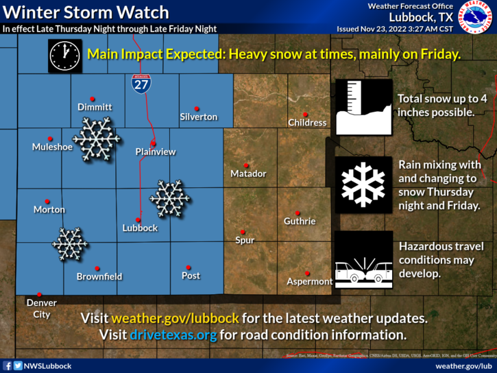
A Winter Storm Watch is in effect for all of the South Plains and much of the far southern Texas Panhandle from late Thursday night through late Friday night. An intensifying storm system has the potential to bring heavy snow at times to much of the region beginning late Thursday night before departing Saturday morning. How soon rain changes over to snow will determine how much snow accumulates, but at this time it appears around 4 inches are possible over much of the Caprock. People with travel plans on Friday should consider making alternate arrangements as hazardous travel conditions are not out of the question. Monitor the latest forecasts for possible winter weather warnings or advisories and follow the latest road conditions at drivetexas.org.
The National Weather Service has issued a Special Weather Statement for these Texas Counties, which includes Terry County. Bailey, Briscoe, Castro, Childress, Cochran, Cottle, Crosby, Dickens, Floyd, Garza, Hale, Hall, Hockley, Kent, King, Lamb, Lubbock, Lynn, Motley, Parmer, Stonewall, Swisher, Terry, and Yoakum Counties
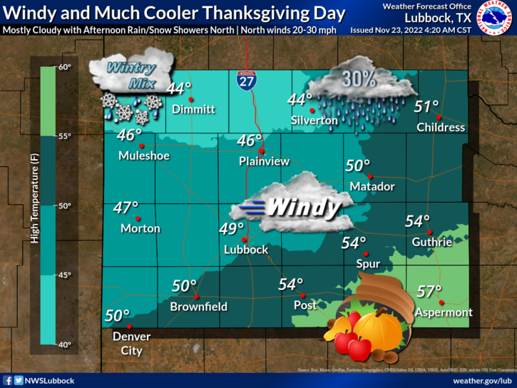
A strong storm system may bring snow accumulations to portions of the South Plains and extreme southern Texas Panhandle on Friday… A strong upper-level storm system is expected to move over the area from late Thursday, November 24, 2022 (Thanksgiving Day) through the day on Friday, November 25, 2022. Precipitation may start off as rain or rain mixed with snow late on Thursday but will quickly switch over to snow early Friday morning for the extreme southwestern Texas Panhandle. A rain/snow mix is expected for a longer period of time for the remainder of the South Plains before turning to mostly snow later on Friday morning. Areas off the Caprock will most likely see mostly rain with little snowfall. Accumulating snowfall may make travel difficult on Friday.
Cities included in the Special Weather Statement that could potentially be affected are Friona, Bovina, Farwell, Dimmitt, Hart, Tulia, Happy, Silverton, Quitaque, Turkey, Memphis, Childress, Kirkland, Muleshoe, Littlefield, Amherst, Olton, Plainview, Hale Center, Floydada, Lockney, Matador, Roaring Springs, Paducah, Morton, Whiteface, Levelland, Sundown, Lubbock, Wolfforth, Slaton, Ralls, Crosbyton, Spur, Dickens, Guthrie, Denver City, Plains, Brownfield, Meadow, Wellman, Tahoka, New Home, ODonnell, Post, Lake Alan Henry, Jayton, Aspermont, and Old Glory
WINTER STORM WATCH IN EFFECT FROM LATE THURSDAY NIGHT THROUGH LATE FRIDAY NIGHT
- WHAT…Heavy snow possible. Total snow accumulations up to 4 inches possible.
- WHERE…Portions of the far southern Texas Panhandle and the South Plains.
- WHEN…From late Thursday night through late Friday night.
- IMPACTS…Roads, and especially bridges and overpasses could become slick and hazardous. Plan on slippery road conditions. The hazardous conditions could impact the Friday morning and evening commutes.
PRECAUTIONARY/PREPAREDNESS ACTIONS
Persons should delay all travel if possible. If travel is absolutely necessary, drive with extreme caution and be prepared for sudden changes in visibility. Leave plenty of room between you and the motorist ahead of you, and allow extra time to reach your destination. Avoid sudden braking or acceleration, and be especially
cautious on hills or when making turns. Make sure your car is winterized and in good working order. Monitor the latest forecasts for updates on this situation.